Ever wondered how those stunning viral videos on TikTok smoothly transition from a single image all the way out to an epic view of our planet? Thanks to advances in AI, you can now create dramatic Earth zoom-out animations in moments—no video editing experience required. FluxPro earth zoom out powered platform or Videoweb earth zoom out powered platform automate the entire process, making it simple for anyone to craft these mesmerizing effects with minimal effort.
Discover the Power of Planet-Scale Zoom Effects
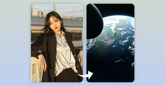
The planet-scale pull-back—where a single image zooms out, revealing its surroundings, city, country, and finally the globe—has become one of the most captivating visual effects in modern content creation. This AI video effect is blowing up on TikTok and Instagram right now. What once demanded expertise in animation or satellite imagery is now accessible to everyone thanks to earth zoom out with Higgsfield AI. This advanced technology empowers creators, marketers, and educators to transform ordinary photos into cinematic journeys from any starting point on Earth.
Why the Earth Zoom-Out Effect Has Captivated Creators
There’s a reason the Earth Zoom-Out effect keeps trending—it’s visually striking and instantly sets content apart. This dynamic transition takes viewers from a close-up perspective to a breathtaking, far-reaching view, elevating a simple moment into something epic. It’s a favorite choice among travel influencers unveiling new locations, vloggers establishing context, or anyone aiming to inject extra energy into their videos.
What Drives Its Viral Appeal?
- Instant Attention-Grabber: The rapid zoom commands the audience’s focus right from the start, making it impossible to look away.
- Hollywood Style: It gives even everyday videos a polished, cinematic touch that rivals big-budget productions.
- Great with Trending Sounds: Dramatic, escalating music syncs naturally with the zoom motion, amplifying emotional impact.
- Highly Adaptable: Whether used as an opening scene, a powerful closing shot, or a seamless bridge between clips, it fits virtually any format or creative style. It’s this combination of flair, versatility, and polish that keeps the Earth Zoom-Out effect at the top of everyone’s must-use list for platforms like TikTok and Instagram Reels.
How to create an earth zoom out video?
You don’t need Adobe After Effects to create this effect anymore—you can do the entire Earth Zoom Out transition right from your phone. We recommend using VideoWeb Earth Zoom Out Effect Video Generator, a beginner-friendly platform that offers the perfect tools and effects to seamlessly achieve this dramatic zoom with ease. Here’s a step-by-step guide to make your own earth zoom out with higgfield ai:
Step 1: Upload Your Starting Image
- Visit the Earth Zoom Out Video page at Fluxpro Higgsfield or VideoWeb.ai.
- Click the upload button to select one or more photos from your device. High-Quality, High-Contrast Images are recommended.
- You can use a building, landmark, or scene image as your starting point. The AI will recognize the subject automatically, establishing the perspective for the zoom effect.
Step 2: Generate the Animation
- After uploading your image, click the “Generate” button.
- The AI combines advanced satellite map stitching, dynamic perspective simulation, and camera path automation to create a smooth, natural zoom-out animation.
- Automatic scene recognition ensures your chosen subject is the center of the zoom.
Step 3: Download and Share
- Once the animation is processed, download your finished Earth Zoom Out video.
- The video will feature high-definition rendering and seamless transitions across multiple zoom levels with no stuttering or breaks.
- Share your creation on social media, use it for video intros, presentations, brand storytelling, or educational content
Key Features of VideoWeb.ai Earth Zoom Out Effect
- Automatic Scene Detection: AI identifies and centers your image’s subject for a natural starting view.
- Multi-Layer Satellite Stitching: Creates fluid, visually impressive transitions from local to global perspectives.
- No Editing Skills Needed: Just upload and generate—no complex video editing required.
- Customizable: Adjust zoom speed and end range as needed for different creative projects. With VideoWeb, transforming a single photo into an epic Earth Zoom Out animation takes just a few clicks—ideal for beginners and professionals alike.
Real-World Applications
Earth zoom out with Higgsfield AI is reshaping digital storytelling for:
| Industry/Use Case | Example Applications |
|---|---|
| Marketing & Branding | Dramatic intros for ads and events |
| Tourism & Real Estate | Location reveals for property tours |
| Social Media Content | Viral TikTok and YouTube shorts |
| Education & Science | Visualizing locations in geography |
| Corporate Presentations | Dynamic team or company intros |
| Environmental Awareness | Showing impact from local to global |
The Future of Visual Storytelling
With ongoing innovations such as real-time satellite integration, augmented reality enhancements, and customizable animation paths, earth zoom out with Higgsfield AI is making professional-grade effects achievable for anyone. Expect even more immersive and interactive content as these tools continue to evolve.
Recommended Reading:
Introducing Earth Zoom Out AI: Transform Any Photo Into a Planet-Scale Pull-Back
Higgsfield AI vs Kling 2.1 Master: Your Guide to AI Video Generation
FAQs
Why choose Fluxpro or Videoweb earth zoom out over Sora?
Fluxpro and Videoweb earth zoom out is an easier and faster AI video maker compared to higgsfield, you can simply upload the image, click the generate button then videoweb will do the rest steps for you.
Do I need to manually stitch maps together?
No, Videoweb automatically stitches multi-layer satellite imagery without requiring manual processing.